Atlantic Road Route Guide: Complete Driving Directions
Complete Route Overview
Official Designation: Norwegian County Road 64 (Fv64)
Total Distance: 8.3 kilometers (5.2 miles)
Driving Time: 15-20 minutes (without stops)
Recommended Experience Time: 2-4 hours with photography and exploration
GPS Coordinates (Storseisundet Bridge): 63.0184°N, 7.3567°E
🗺️ Navigation Essential
Start Point: Vevang (mainland connection)
End Point: Averøy Island
Speed Limit: 80 km/h (50 mph)
Road Surface: Excellent paved conditions year-round
GPS Setting: Use "Atlanterhavsveien" or "Atlantic Road, Norway"
Detailed Turn-by-Turn Directions
Northern Approach: From Kristiansund
Starting Point: Kristiansund city center
Distance to Atlantic Road: 45 kilometers (30 minutes)
Step-by-Step Directions:
- From Kristiansund centrum: Head south on Langveien (Route 70) toward Averøy
- Continue 15 km: Follow signs for "Atlanterhavsveien" and "Averøy"
- Turn right onto Route 64: Clear signage indicates "Atlantic Road/Atlanterhavsveien"
- Drive 8 km through Averøy: Pass local communities and traditional Norwegian coastal architecture
- Atlantic Road begins: Official start marked by information boards and parking area
Southern Approach: From Molde
Starting Point: Molde city center
Distance to Atlantic Road: 65 kilometers (1 hour)
Step-by-Step Directions:
- From Molde centrum: Take E39 east toward Åndalsnes
- After 15 km: Exit onto Route 64 north (signed "Kristiansund/Atlanterhavsveien")
- Continue 35 km: Scenic drive through rural Norwegian landscape
- Tunnel approach: Enter 5.7 km Atlanterhavstunnelen (toll tunnel: 139 NOK for cars)
- Exit tunnel: Continue straight on Route 64 toward Atlantic Road
- Vevang approach: Atlantic Road begins 5 km after tunnel exit
🚧 Tunnel Information
Atlanterhavstunnelen Details:
Length: 5.7 kilometers under the Atlantic Ocean
Toll: 139 NOK (cars), 279 NOK (motorhomes)
Payment: AutoPASS electronic system or manual payment
Depth: Up to 250 meters below sea level
The Eight Bridges: Detailed Guide
Bridge Sequence (South to North)
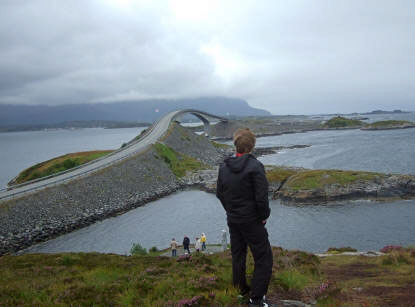
1. Storseisundet Bridge (Famous "Bridge to Nowhere")
GPS: 63.0184°N, 7.3567°E
Length: 260 meters
Height: 23 meters above sea level
Special Feature: Curved design creates optical illusion from specific angles
2. Geitøysundet Bridge
GPS: 63.0201°N, 7.3612°E
Length: 108 meters
Connects: Geitøya island to the main route
3. Hulvågen Bridge
GPS: 63.0215°N, 7.3651°E
Length: 85 meters
Feature: Lowest bridge with excellent seal watching opportunities below
4. Kvernes Bridge
GPS: 63.0234°N, 7.3701°E
Length: 115 meters
View: Panoramic Atlantic Ocean vista point
5. Averøysundet Bridge
GPS: 63.0251°N, 7.3742°E
Length: 142 meters
Significance: Connects to Averøy Island proper
6. Vevangstraumen Bridge
GPS: 63.0268°N, 7.3783°E
Length: 95 meters
Feature: Traditional Norwegian fishing boat harbor views
7. Strømsholmen Bridge
GPS: 63.0285°N, 7.3824°E
Length: 78 meters
Access: Sea sports center and activity booking point
8. Final Bridge (Northern Terminus)
GPS: 63.0302°N, 7.3865°E
Length: 67 meters
Completion: Connection to mainland Romsdal peninsula
Strategic Stopping Points & Parking
Major Viewpoints with Facilities
Eldhusøya Walking Path & Viewpoint
GPS: 63.0195°N, 7.3598°E
Facilities: Large parking area (50+ cars), restrooms, information center
Features: Elevated boardwalk, 360-degree views, wheelchair accessible sections
Photography: Best overall perspective of bridge system
Storseisundet Bridge Parking (South Side)
GPS: 63.0175°N, 7.3545°E
Capacity: 30 cars, 5 motorhome spaces
Best For: Classic "Bridge to Nowhere" photography angle
Walking Distance: 200 meters to optimal viewpoint
Strømsholmen Activity Center
GPS: 63.0288°N, 7.3827°E
Services: Parking, boat tours, equipment rental, café
Activities: Seal safaris, fishing tours, kayak rental
Contact: +47 71 51 46 78
📸 Photography Zones
Golden Hour Locations:
• Sunrise: East-facing viewpoints near Kvernes Bridge
• Sunset: West-facing positions at Eldhusøya walkway
• Storm Photography: Sheltered viewing areas with safety barriers
• Drone Restrictions: Check current regulations at visitor centers
Seasonal Route Considerations
Summer Driving (June-August)
Peak Season Challenges:
• Heavy tourist traffic, especially weekends
• Parking areas fill quickly (arrive before 10:00 AM)
• Extended daylight hours allow flexible timing
• All viewpoints and facilities fully operational
Recommended Summer Strategy:
Early morning visits (6:00-9:00 AM) provide optimal lighting and minimal crowds. Midnight sun photography opportunities during midsummer create unique experiences.
Winter Driving (November-March)
Winter Conditions:
• Mandatory winter tires and possible chain requirements
• Strong Atlantic storms create dramatic wave action
• Reduced daylight hours but potential Northern Lights viewing
• Some parking areas may have limited snow clearing
Detailed winter driving safety information and storm watching protocols are available in our winter Atlantic Road guide.
Shoulder Season Benefits (April-May, September-October)
Optimal balance of weather conditions, moderate traffic, and excellent photography lighting. Many consider these months ideal for Atlantic Road experiences.
Safety & Driving Protocols
Weather-Related Precautions
High Wind Conditions:
Atlantic Road experiences frequent strong winds. High-profile vehicles (motorhomes, motorcycles) should monitor weather forecasts and consider delaying travel during wind warnings exceeding 15 m/s (54 km/h).
Storm Weather Safety:
During severe Atlantic storms, waves can reach bridge deck levels. Observe all safety barriers and warnings. Storm watching should only be attempted from designated safe viewing areas with proper facilities.
⚠️ Critical Safety Information
Emergency Contacts: 112 (general emergency), 120 (sea rescue)
Weather Monitoring: yr.no for local conditions
Road Conditions: +47 175 (traffic information hotline)
Never: Stop on bridges for photography or sightseeing
Alternative Routes & Connections
Extended Coastal Circuit
Combine Atlantic Road with other Norwegian Scenic Routes for comprehensive coastal experiences:
Trollstigen Connection (Seasonal)
Distance: +120 km
Features: Dramatic mountain hairpins, Geirangerfjord access
Season: May-October (weather dependent)
Geiranger-Trollstigen National Tourist Route
Total Circuit: 200+ km from Atlantic Road
Highlights: UNESCO World Heritage fjord landscapes
Planning: Full-day extension requiring overnight accommodation
Ferry Integration Options
Molde-Vestnes Ferry Connection
Alternative approach avoiding tunnel tolls
Scenic fjord crossing with additional sightseeing value
Schedule: Frequent daily service, advance booking recommended in summer
GPS Coordinates Summary
Key Navigation Points:
- Atlantic Road Southern Entrance: 63.0165°N, 7.3525°E
- Storseisundet Bridge Center: 63.0184°N, 7.3567°E
- Eldhusøya Viewpoint Parking: 63.0195°N, 7.3598°E
- Strømsholmen Activity Center: 63.0288°N, 7.3827°E
- Northern Atlantic Road Terminus: 63.0315°N, 7.3885°E
Route Planning Resources
Digital Planning Tools:
• Google Maps: "Atlantic Road, Norway" provides accurate routing
• Offline Maps: Download Maps.me for areas with limited cell coverage
• Weather Apps: YR.no for hyperlocal Atlantic Road conditions
• Traffic Updates: Norwegian Public Roads Administration app
For comprehensive trip planning including accommodation booking, activity scheduling, and seasonal recommendations, consult our complete Atlantic Road planning guide. Professional photography techniques and optimal timing information are detailed in our photography guide.
The Atlantic Road route transforms a simple drive into an unforgettable journey across Norway's dramatic coastal landscape. Whether seeking adventure, photography opportunities, or peaceful contemplation, these detailed directions ensure you experience every moment of this world-renowned scenic drive.